Topographycal services

TOPOGRAPHICAL MAPPING

Topographic survey is a research activity to assess the natural surface conditions on the ground at the expected area for planning, designing, volume excavation calculation and embankment work.

Topographical mapping

Why choose GOSCO

Progress

Always try to complete the job with the fastest progress and quality assurance

General information

TOPOGRAPHICAL MAPPING

Topographical mapping is to determine the relative positions of measured objects (topographical characteristics, terrain, architectural works) on the field and then use the map symbols to represent them on the plane according to a certain ratio.


When measuring and drawing the topography, it is necessary to base on the national control landmarks, thereby settup the project control network to serve the detailed measurement of the terrain.


GOSCO - Đo vẽ mặt cắt địa hình-Section measurement-2

At present, topographic work can be done by the following common methods:

  • Instrument:

+ The Total station is a surveying instrument that is commonly used. It is a combination of processor, memory and electronic theodolite.
+ We can use these angles and distances to determine the accurate position of the surveyed point and solve mathematics geodetics.
+ Total station: Leica TS06 Plus

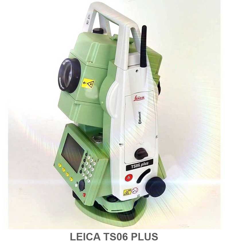
  • Measurement methods: Prism and Reflectorless Total Stations
  • Applications:

+ Apply measuring survey points: To measure angles (horizontal and vertical angles); measure distance, measure elevation.
+ Measurement: cadastral, topography and construction, detailed measurement and mapping.

  • Advantage:

+ Accuracy of measurement is high.

+ Quick calculation without taking notes.

+ Easy to transfer measurement data to the computer.

  • Disadvantage:

+ Need to see clearly from the device to the desired point.

+ It needs times to measure and draw large area maps.

+ The instrument is costly.

+ Measurements are affected by weather.


[vi:]

  • Công nghệ GPS:

GPS (Global Positioning System – Hệ thống định vị toàn cầu), dựa vào hệ thống vệ tinh nhân tạo bay xung quang trái đất. GPS lần đầu được phát triển để phục vụ mục đích quân sự vào những năm 1970. Kể từ năm những năm 1990 công nghê GPS được phép ứng dụng trong dân sự, đến nay công nghệ GPS ngày càng được phát triển và áp dụng trong nhiều lĩnh vực, đặc biệt công nghệ GPS là một bước tiến quan trọng trong công tác khảo sát trắc địa.


  • Phương pháp đo đạc:

Các dữ liệu từ vệ tinh được thu nhận và xử lý tùy vào mục đích sử dụng. Ngoài mục đích sử dụng dữ liệu định hướng, dự liệu GPS được sử dụng để đo giữa các điểm. Các phép đo này được thu thập sau đó được lưu trữ, xử lý và hiển thị trong hệ thống thông tin địa lý, hoặc GIS, để sử dụng trong mô hình khảo sát.
+ 3 phương pháp chính trong việc sử dụng GPS để đo khảo sát:

1. Đường cơ sở GPS tĩnh:

Phương pháp được sử dụng để xác định tọa độ chính xác cho các điểm khảo sát bằng cách ghi lại đồng thời các quan sát GPS qua một điểm khảo sát đã biết và chưa biết trong ít nhất 20 phút. Dữ liệu sau đó được xử lý tại văn phòng để cho ra tọa độ với độ chính xác cao hơn 5mm tùy thuộc vào thời gian quan sát và tính khả dụng của vệ tinh tại thời điểm đo.

2. Đo động thời gian thực (RTK- Real-time kinematic):
Phương pháp sử dụng một đầu thu tại một điểm đã biết – Điểm cơ sở (the Base Station). Một đầu thu khác được di chuyển để đo những điểm cần đo – the Rover Station. Những điểm đo có thể được tính toán và lưu trong vài giây, sử dụng liên kết vô tuyến (radio) để cung cấp hiệu chỉnh tọa độ. Phương pháp này cho độ chính xác tương tự với các phép đo cơ sở trong phạm vi 10km tính từ trạm gốc.
3. Đo sử dụng hệ thống trạm tham chiếu GNSS (Continuously Operating Reference Stations – CORS)
Phương pháp sử dụng trạm GPS được xây dựng cố định tại một vị trí được chọn làm điểm bắt đầu để từ đó đo các điểm khác trong khu vực trạm CORS. Các trạm CORS được xậy dựng trong khu mỏ, những dự án lớn và chính quyển địa phương. Tại Việt Nam, trạm CORS được xây dựng bởi một số doanh nghiệp tư nhân, Bộ Tài nguyên và Môi trường.


Each drawing method has its own advantages and disadvantages. Depending on topographical conditions, study areas, it can be applied one or more suitable measuring methods.
GOSCO has well trained topographical engineers with many years of experience in the field of construction consultancy, construction survey especially experienced in the survey work for power projects including thermal electricity, wind power, hydropower, solar power, combined with modern equipment such as single-beam echo sounder, two-frequency GSP (RTK), total station equipment, electronic levelling equipment, we ensure to provide high reliability of topographical mapping, bathymetry services, meeting urgent projects with competitive costs.